Six new protected areas created in Brazilian Amazonian state
On this Thursday, March 26th, the Amazonas state government will announce the new areas, totaling over 2.3 million hectares. They will complete the protected area mosaic in the BR-319 highway area of influence.
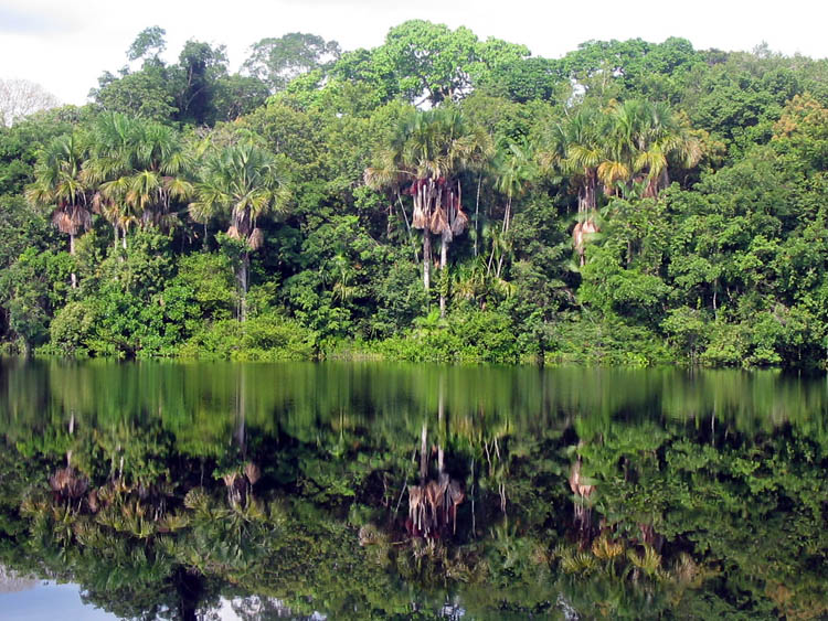
Photo: Julie Griffin, November 2003
The creation of over 2.3 million hectares of new protected areas in Amazonas state, in Brazil, will be officially announced on Thursday, the 26th March. These six new protected areas created by the state government add to the mosaic of protected areas which already exists in the BR-319 highway area of influence. Five federal protected areas were created last year and one other was enlarged in the highway area, totaling 5.5 million hectares. The new announced areas include a state park, an “extractive reserve” (a community based sustainable use area), two sustainable development reserves, and two public forests.
This protected area mosaic created in the BR-319 highway area of influence is crucial to stop the pressure on the environment due to the fact that the highway will eventually be paved. Mosaics make it possible to have an integrated management for a group of protected areas by sharing the equipment, infrastructure and human resources. Besides making viable a more efficient management, the protected area mosaic around the BR-319 highway provides a large continuous area for environmental protection which is more representative of the local biodiversity and acts as a protective barrier against deforestation.
According to WWF-Brazil studies, in order to ensure conservation of an ecologically representative sample of biological diversity, it is necessary to protect around 30% of the Brazilian Amazon. Nevertheless, to maintain the ecological flows, processes and services – which are most relevant in this climate change scenario – it is necessary to conserve 60% of the Amazon. Deforestation fight and reduction strategies must cover several action fronts and highlight the creation of protected areas. Special attention, however, ought to be given to the illegal land market and the attraction poles, such as large infrastructure and highway pavement works.
Brazilian Environment Minister, Carlos Minc, announced last year, in September, that the highway license process had been interrupted until a new plan was made to implement the protected areas along the road. To justify this measure, the Minister pointed out that it is a fact that the works for paving the highway serves as an incentive to deforestation. That was the case in the BR-163 highway area, where a mere announcement that the highway was going to be paved caused deforestation to increase by 500%.
In the BR-319 case, the federal government efforts to stop the pressure on the environment can now count on this relevant Amazonas state government initiative to create six state protected areas”, says WWF-Brazil’s CEO, Denise Hamú. She explains that “these areas are crucial to keep a representative sample of the region’s biodiversity, as they include some of the least protected Amazonian environments – such as the seasonally flooded white sand savannas campinas. They are located among the Purus and Madeira river valleys and will help to protect the great variety of fish found there. They will also help maintain the way of living of a relevant amount of communities dwelling along the river banks and making a living out of oil and rubber extraction plus collecting Brazil nuts”.
The creation of both federal and state protected areas composing the mosaic was decided upon following six public hearings which took place in July 2006, in Amazonas state municipal districts. During those meetings and with the support of WWF-Brazil and the Amazon Protected Area – ARPA Program, the representatives from the business sector, the community associations and the population in general could voice their opinion on the subject. The protected area creation and category were chosen based on the consultations made during the public hearings.
According to WWF-Brazil’s CEO, however, the mere creation of protected areas does not ensure the desired environmental protection. After officially creating the protected areas, it is necessary to make all efforts to actually implement them. The most urgent step is the allocation of personnel to manage the areas. Then it is also crucial to clearly define the limits of each area, to reimburse eventual legal occupants and to seek actual land use concession for local communities. The management boards must be composed and their capacity built”, says Denise Hamú.
To fulfill these protected area implementation steps, the BR-319 mosaic counts on the support of the ARPA Program. Four out of the six new protected areas created by the Amazonas state government can be included in the ARPA Program. Two out of six protected areas created by the federal government were included among those which are directly supported by ARPA, while two others can still be included. Besides supporting ARPA, WWF-Brazil has contributed to implement this mosaic and other ones, systematizing and disseminating lessons learned by the various actors involved with this type of protected areas joint management strategy.
Ceremony
The new protected areas launching event will take place at the 6th Civil Engineering Battalion, located at km 215 on BR-319 highway. The state governor, Eduardo Braga, and the Transports Minister, Alfredo Pereira do Nascimento, will take part in the ceremony, as well as the Amazonas state secretary for the Environment and Sustainable Development, Nadia Cristina D’Ávila Ferreira, and WWF-Brazil’s Conservation Director, Cláudio Maretti. Right after the creation of the protected areas is made official in the field, the Amazonas state governor and his guests will go back to Manaus for the creation of the Amazonas Global Forum on Climate Change, Biodiversity and Environmental Services. The state government wants the Forum to be a discussion space for climate change and related themes, such as energy biodiversity, forests and environmental services.
|
State PAs |
||||
|
|
NAME |
CATEGORY |
AREA (ha) |
MUNICIPAL DISTRICTS |
|
1 |
IGAPÓ-AÇU |
RDS* |
394,622.96 |
BERURI/BORBA/MANICORÉ |
|
2 |
MATUPIRI |
RDS* |
179,083.45 |
BORBA |
|
3 |
MATUPIRI |
STATE PARK |
509,591.67 |
MANICORÉ/BORBA |
|
4 |
TAPAUÁ |
PUBLIC FOREST |
881,704.00 |
TAPAUÁ/CANUTAMA |
|
5 |
CANUTAMA |
PUBLIC FOREST |
150,588.57 |
CANUTAMA/TAPAUÁ |
|
6 |
CANUTAMA |
RESEX** |
197,986.50 |
CANUTAMA/TAPAUÁ |
|
STATE TOTAL |
2,313,577.15 |
|
||
|
FEDERAL PAs |
||||
|
|
NAME |
CATEGORY |
AREA (ha) |
MUNICIPAL DISTRICTS |
|
7 |
JARI LAKE HEADWATERS |
NATIONAL PARK |
812,141.00 |
TAPAUÁ/BERURI |
|
8 |
BALATA-TUFARI (enlargement) |
PUBLIC FOREST |
275,836.00 |
CANUTAMA |
|
9 |
MAPINGUARI |
NATIONAL PARK |
1,639,829.18 |
CANUTAMA/LÁBREA |
|
10 |
ITUXI |
RESEX** |
796,485.65 |
LÁBREA |
|
11 |
IQUIRI |
PUBLIC FOREST |
1,422,775.23 |
LÁBREA |
|
12 |
MID PURUS |
RESEX** |
604,209.00 |
LÁBREA/PAUINI |
|
FEDERAL TOTAL |
5,551,276.06 |
|
||
|
|
||||
|
TOTAL |
7,864,853.21 |
|
||
**Resex – extractive reserve (community sustainable use)
For further information:
WWF-Brazil’s Communications
denisecunha@wwf.org.br
isadora@wwf.org.br
maristela@wwf.org.br
Related content
Le Plan national de développement du Burkina Faso entend dynamiser des secteurs tels que l’…
Dans le cadre de la mise en œuvre du Projet de Facilitation d’Engagement pour la Biodiversité…
Les nouvelles CEESP: Emmanuel Mvé Mebia, membre du IUCN CEESP. Basé sur les recommandations…

S’abonner à un bulletin de l’UICN.