A Training Workshop on Geographic Information and Map Data Use for Planning Officers in the Northern Province
A special Training Workshop on Geographic Information and Map Data Use was conducted at the University of Uva Wellassa in Badulla from 8-10 June 2018.
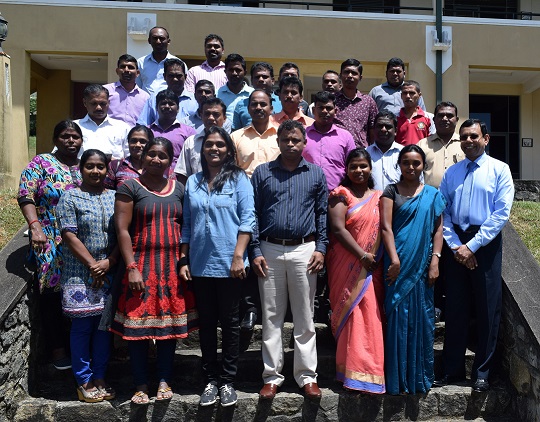
Participants at the completion of the training programme
Photo: IUCNSL
Twenty-Seven Planning Officers (16 male and 11 female) representing 17 organizations from the Northern Province, which included District Secretariats of Jaffna, Mannar and Mullaitivu, several Divisional Secretariats, Land use Policy Planning Departments of the five districts in the Northern Province, Forest Department, Department of Archaeology, Central Environmental Authority, Centre for Research and Development of the Ministry of Defence participated in the workshop.
The workshop was part of the project on “Integrated Strategic Environment Assessment for the Northern Province of Sri Lanka (ISEA-North): Lessons Learned”, funded by the UN Environment, which focused on understanding the implementation experience of the ISEA-North conducted from November 2009 to April 2012 in five districts of the Northern Province of Sri Lanka: Jaffna, Kilinochchi, Mannar, Mullaitivu and Vauvniya.
During the process of understanding the implementation experience of the ISEA-North, the need to train planning staff on Geographic Information Systems (GIS) was identified, leading to the culmination of this three day workshop. QGIS—a cross-platform, free and open-source user friendly desktop GIS application that supports viewing, editing, manipulating and analysing of geospatial data—was selected for this training. It is a proven alternative to commercial GIS packages, and therefore, will assist the participants to use GIS in the future without restrictions or licencing needs. The training programme which was conducted by staff of the University of Uva Wellassa was assisted by the Dept. of Land Use Policy Planning and the Survey Department.
The participants highlighted the importance of the training programme and the specific tool, as QGIS software is very user-friendly. The programme will assist them in making decisions by applying for disaster management and for land use planning. The workshop emphasised the need to involve continuous capacity building of Government and other structures, especially after post-crisis situations to promote and facilitate the rebuilding processes.
Related content
A workshop to engage and empower the Economic Development Officers (EDOs) to conserve and manage…
More than 100 conservation and development practitioners attended the Critical Ecosystem…
A leading cement manufacturer in Sri Lanka Siam City Cement (Lanka) Ltd, also known as INSEE Cement…

S’abonner à un bulletin de l’UICN.